Super El Niño Winter 2026-27: Forecast, Impacts and What to Expect
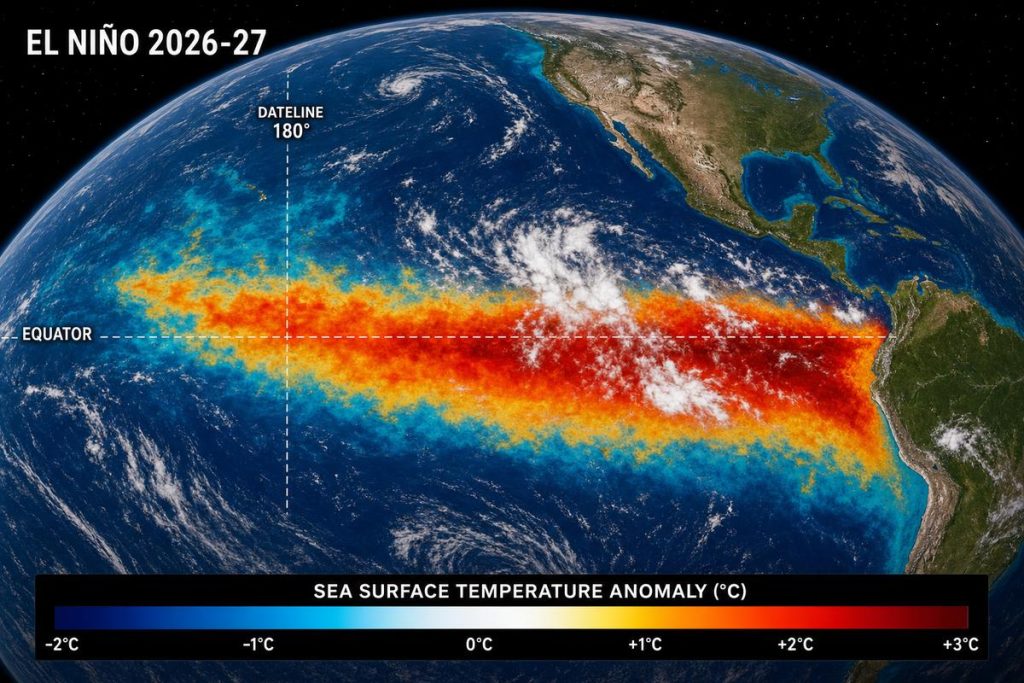
Super El Nio Winter 2026-27 Image: The Daily Reads Image Team
A historic super El Niño is strengthening. See NOAA’s 2026-27 winter forecast, how it affects your state, heating costs, floods, snow and ski season, plus answers to 20 common questions.
What Is the Super El Niño Winter Forecast?
A very strong El Niño is building in the Pacific Ocean, and forecasters say it could be the strongest in records going back to 1950. NOAA’s official 2026-27 winter outlook, released October 16, favors a wetter, stormier winter across the Southwest, the South and the East Coast, and a warmer-than-average winter across the northern U.S., including the Pacific Northwest, northern Rockies and Midwest.
That is a forecast of odds, not a guarantee. Every El Niño plays out a little differently, and this one is stronger than anything scientists have measured before.
Key Takeaways
- It is already official. NOAA has had an El Niño Advisory in effect since the event formed this summer, and its October 8 update says the event is still strengthening.
- Historic strength is likely. NOAA gives about an 83% chance that the October-December period will beat every El Niño since 1950.
- The South gets the storms. The jet stream shifts south and east, which tilts the odds toward heavy rain across California, the Southern Tier and the Southeast.
- The North gets the mild weather. Much of the northern U.S. is favored to run warmer than normal.
- Heating bills look mixed. Households using natural gas or propane are expected to spend less than last winter, while heating oil users are expected to pay roughly a fifth more.
- California is the biggest wild card. Atmospheric rivers could bring flooding and mudslides at low elevations and big snow in the Sierra.
- Next checkpoint: NOAA’s next El Niño update is scheduled for November 12, 2026.
What Is a Super El Niño?
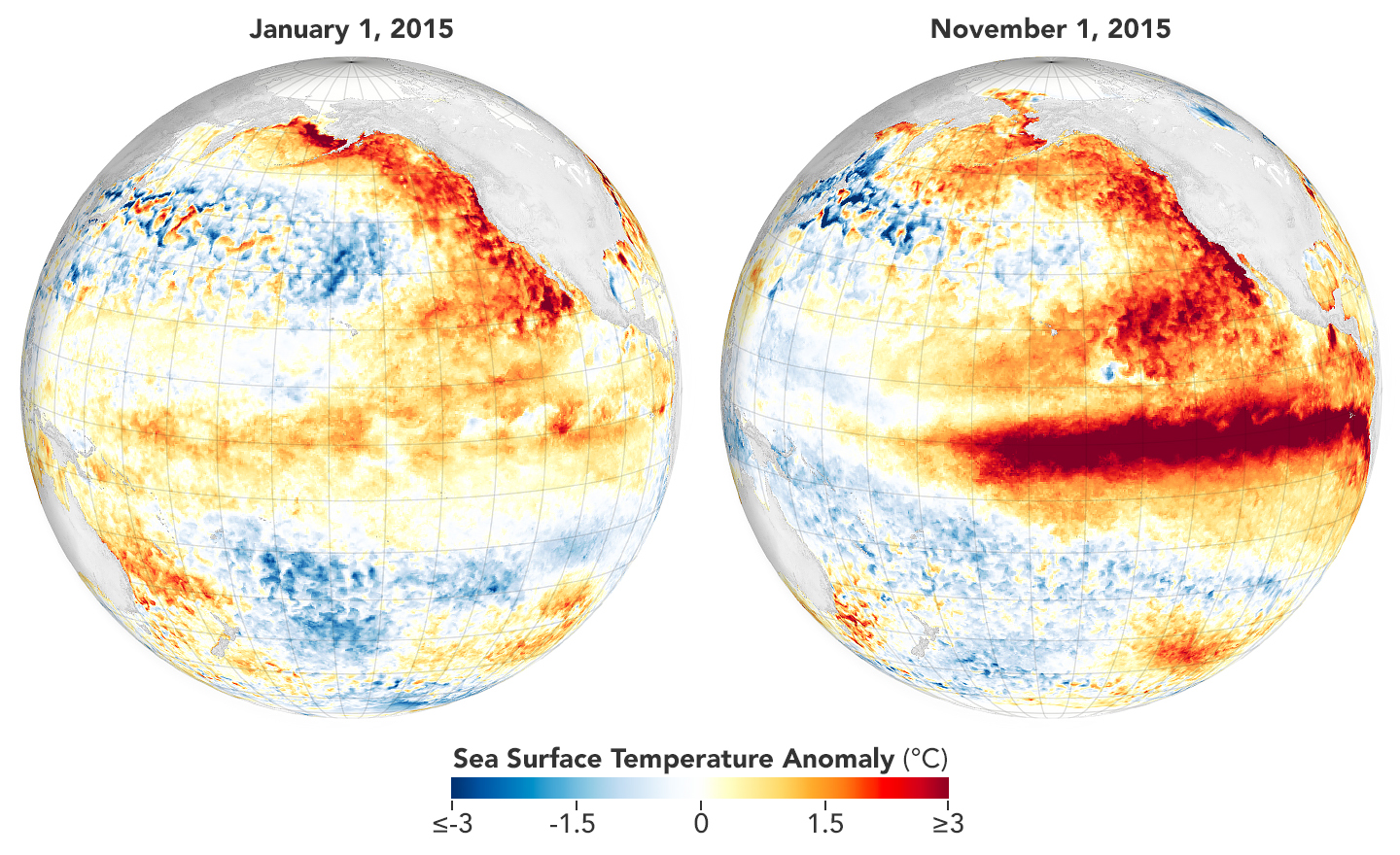
El Niño is a natural climate pattern in which the surface of the tropical Pacific Ocean runs warmer than normal. NASA describes it as something that shows up roughly every two to seven years, and when it does, it shifts trade winds, moves heat around the ocean, scrambles rainfall patterns and raises sea levels across parts of the Pacific.
“Super El Niño” is a nickname, not an official category. NOAA does not use the term. The informal rule of thumb is that an El Niño qualifies as “super” when the key ocean temperature measure stays about 2.0°C or more above normal for three months in a row. Forecasters use the label to describe the very top tier of events, like the ones in 1982-83 and 1997-98.
One technical change matters for this story. NOAA now judges El Niño strength using a relative index (called RONI), which subtracts the background warming of the whole tropics. That way, long-term global warming does not make every El Niño look stronger than it really is. Under this newer scale, NOAA counts a historic event as one reaching +2.5°C or more over a three-month period.
Where Things Stand Right Now (October 2026)
Here is what the most recent official data shows.
- NOAA’s October 8 update: The agency reported that El Niño strengthened further in September, with ocean temperatures in parts of the eastern equatorial Pacific running more than 4°C above average. The headline measure for the central Pacific (the Niño-3.4 region) reached +2.1°C, while the Niño-3 region hit +3.0°C and the Niño-1+2 region hit +3.9°C.
- Strength forecast: NOAA says a strong-to-very-strong El Niño is likely through January-March 2027, with that outlook holding above an 83% chance. It expects El Niño to continue strengthening through the end of the year and to persist into spring (March-May 2027).
- Odds of a record: The chance of reaching historic strength is 54% for September-November, 83% for October-December and 70% for November-January.
- NASA’s view: As of mid-October, NASA says satellites are tracking what it describes as an unfolding historic event, with NOAA putting the odds of the strongest El Niño since 1950 at 83%.
- Independent trackers: Sites that track NOAA’s weekly data report even higher readings on the older, non-relative scale, with the week of October 7 coming in around +3.3°C. Treat those as a secondary source and check NOAA directly for official numbers.
Forecasters add one caution. Even a very strong event does not guarantee classic El Niño weather in every location. It changes the odds, and the biggest impacts usually peak between about December and February.
NOAA’s Official 2026-27 Winter Outlook
NOAA released its U.S. Winter Outlook on October 16, covering the December-February period.
Wetter than average: The Southwest, the South and the East Coast.
Warmer than average: The Pacific Northwest, northern Rockies, northern California, the Midwest, the Mississippi Valley, much of the eastern U.S. and Alaska.
National Weather Service Director Ken Graham explained the reasoning in simple terms: a very strong El Niño typically shifts the jet stream south and east over the lower 48, which makes stormier weather across the South more likely.
One important detail from the science side: the warmth in the forecast is not all El Niño. The long-term warming trend is also pushing odds toward above-average temperatures across more than half the country, and El Niño adds to it for the winter.
Region-by-Region: What the Super El Niño Could Mean for Your Area
California and the Southwest
This is where forecasters expect the most dramatic impacts. A southerly storm track can send repeated Pacific storms at the coast, including atmospheric rivers, which are long corridors of moisture that NOAA describes as “rivers in the sky.” AccuWeather called the flood threat serious enough this year that it added a flood-risk map to its winter forecast for the first time, highlighting the California coast and then the southern half of the country into the Southeast.
Why it matters: California gets most of its yearly precipitation from a handful of big storms, so even a few strong atmospheric rivers can define the whole season. Risks include flooding, mudslides (especially on slopes scarred by past wildfires), coastal erosion and high surf. On the upside, heavy mountain snow could help water supplies.
The caveat: the last super El Niño, in 2015-16, did not deliver the soaking many people expected in parts of California. Forecasts favor wet, but they are not a promise.
The South and Gulf Coast
NOAA favors wetter-than-average conditions across the Southern Tier from Texas to Florida. That means a higher chance of heavy rain events and flash flooding, and it could help ease drought in places that have been dry. Severe thunderstorms and storm-related travel disruption are possible, so keep an eye on local National Weather Service forecasts.
The East Coast and Northeast
Much of the East Coast is favored to be wetter than normal. Temperatures are expected to lean warmer than average, which can mean more rain and less snow in some spots, although individual nor’easters can still hit. Forecasters also flag a risk of coastal flooding and beach erosion from strong late-winter storms.
The Midwest and Northern Plains
The Midwest and the Mississippi Valley are favored to run warmer than normal. AccuWeather expects the storm track to bring better snow chances across the Plains in January and February, after a quieter start to winter. A milder winter does not rule out a major snowstorm or a cold snap. It just makes extreme cold less likely on average.
The Pacific Northwest and Northern Rockies
These regions are favored to be warmer than normal. For skiers, the risk is higher snow levels and rain-on-snow events during Pacific storms.
Will This Winter Be Cold or Warm?
For most of the northern half of the country, the odds favor warmer than normal. For the South, the story is wetter, with temperatures varying more by storm. The EIA, the federal energy agency, said earlier in October that it expects national winter temperatures to look roughly like last winter and the 10-year average, but added that a strong El Niño could produce different outcomes. In other words, expect a mild lean, not a guaranteed warm winter.
Snow and Ski Season Outlook
The West had one of its worst snow seasons on record last winter, so skiers have a lot riding on this one.
- Early start in the West: AccuWeather expects the snow season to begin early from the Sierra Nevada through the Great Basin and into the central and southern Rockies.
- Southwest favored: OpenSnow’s forecast favors above-normal snowfall across California, Utah, Arizona, New Mexico and parts of Colorado.
- The warm-storm risk: El Niño atmospheric rivers can carry warm, subtropical air. That means huge precipitation totals but also rain at lower elevations and fluctuating snow levels.
- Plains snow later: Better chances arrive in January and February.
OpenSnow also reminds travelers that the 15-day forecast is more reliable than any seasonal outlook when you are planning a specific ski trip.
Heating Costs and Energy Prices This Winter
This is the part of the forecast that hits your wallet.
- Natural gas and propane (about half of U.S. households): The EIA expects these households to spend less than last winter. Gas storage is slightly above its five-year average, which acts as a cushion.
- Heating oil households: The EIA forecasts about 21% higher fuel costs than last winter, because distillate markets are tight. Milder weather in the Northeast offsets part of a price increase that would otherwise top 30%.
- Natural gas futures: Reuters reported that futures for December through February averaged about $3.49 per million BTU, down from about $3.96 for the same period last winter. Analysts expect the Henry Hub benchmark to average around $3.50, roughly 12% below last winter, because mild weather would cut demand.
- The wild card: Growing LNG exports and rising power-sector demand could limit how far prices fall, and a sudden cold snap would still push bills up.
The Economic and Safety Picture
Beyond heating bills, forecasters and insurers are watching a few specific risks.
- Flood insurance timing: Standard homeowners policies generally do not cover flood damage. Federal flood insurance typically has a 30-day waiting period, so a policy bought in late November may not be active until late December, after the first storms. Check with your insurer or agent now.
- Burn scars: Areas in California scarred by recent wildfires are especially vulnerable to debris flows when heavy rain hits.
- Coastal damage: Large waves and high tides can erode beaches and damage roads, cliffs and waterfront property.
- Wildfire relief: On the plus side, more rain could reduce wildfire risk in Southern California by keeping vegetation and soil moist.
How to Prepare for a Super El Niño Winter
These steps make sense for most households, depending on where you live.
- Check flood coverage now. Ask whether your policy covers flooding and remember the waiting period.
- Know your flood and landslide risk. Look up your address on FEMA’s flood map and your local emergency management site.
- Clear gutters, drains and storm channels before the rainy season peaks.
- Build or restock an emergency kit: water, food, medications, flashlights, batteries, chargers and important documents.
- Lock in a heating plan. If you use heating oil, ask your supplier about fixed-price or capped-price contracts. Gas and propane users can ask about budget billing.
- Sign up for local alerts from the National Weather Service and your county or city.
- Plan travel with flexibility. If you fly or drive through storm-prone regions, book refundable options when possible.
- Winterize your home and car the way you normally would. A mild forecast does not eliminate cold snaps.
Frequently Asked Questions About the Super El Niño Winter
What is a super El Niño in simple words?
It is an unusually strong version of El Niño, a natural warming of the tropical Pacific Ocean that changes weather patterns around the world. “Super” is an informal nickname used when ocean temperatures run about 2°C or more above normal for roughly three months.
Is a super El Niño officially happening in 2026?
An El Niño is officially underway, and NOAA has an El Niño Advisory in effect. Whether it ends up being a “super” event is still being decided, since the term is informal and the event is still strengthening. NOAA gives about an 83% chance of record strength for October-December.
How strong is this El Niño compared to past ones?
NOAA says there is a high chance it will be the strongest since records began in 1950. AccuWeather’s long-range expert said it is almost certain to surpass the major events of 1982-83 and 1997-98.
When will the super El Niño peak?
El Niño events tend to peak between about October and February. AccuWeather says this one may reach historic levels in December or January, and NOAA expects it to keep strengthening through the end of 2026 and last into spring 2027.
What does NOAA’s winter forecast say?
NOAA’s outlook, released October 16, favors wetter-than-average conditions across the Southwest, the South and the East Coast, and warmer-than-average conditions across the northern U.S. and much of the East from December through February.
Will this winter be colder than normal?
Most of the country is not favored for a colder-than-normal winter. The northern U.S. leans warmer, and the South leans wetter. Individual cold snaps can still happen.
Will it snow more this winter?
It depends on where you live. The Southwest, including parts of California, Utah and Colorado, is favored for above-normal snowfall, and the Plains could get more snow in January and February. Warm, rainy storms may cut snowfall at lower elevations in the Pacific Northwest and the East.
Will California get floods this winter?
The risk is elevated. Forecasters expect a stormier pattern with a chance of repeated atmospheric rivers, and AccuWeather flagged the California coast as a main flood-risk area. The 2015-16 event showed it is not guaranteed, but residents near rivers, coasts and burn scars should prepare.
What is an atmospheric river?
It is a long, narrow band of moisture in the atmosphere that carries huge amounts of water vapor from the tropics to places like California. When it hits land, it can produce heavy rain and mountain snow.
Will El Niño end the drought?
It could help in places that get a wetter-than-normal winter, especially the South and Southwest. But even a very strong El Niño does not guarantee relief everywhere. For example, parts of the Colorado River Basin may or may not benefit, because Colorado can have a wet winter statewide while some key headwater areas get less snow.
How will El Niño affect heating bills?
The EIA expects households that heat with natural gas or propane to spend less than last winter, while heating oil households are expected to pay about 21% more. Mild weather in the Northeast and Midwest would reduce demand and help.
Will gas and electricity prices fall?
Analysts expect natural gas to be cheaper this winter than last, which could help hold down power bills, since about 40% of U.S. electricity comes from gas-fired plants. But rising LNG exports and demand from power plants may limit the drop.
How does El Niño affect hurricanes?
El Niño typically adds wind shear over the Atlantic, which tends to suppress hurricane activity there. The Atlantic season officially ends November 30, so it matters little for the winter ahead.
Will there be more tornadoes or severe storms?
Some El Niño winters raise the odds of severe weather in parts of the Gulf Coast and Florida, but the evidence is mixed. Follow your local National Weather Service office for warnings.
Is the super El Niño caused by climate change?
El Niño is a natural cycle. However, scientists say the long-term warming of the oceans is adding to the heat on top of the natural event, which is why NOAA now uses a relative index to measure strength.
Will 2027 be the hottest year on record?
El Niño tends to raise global temperatures, and the biggest effect usually shows up in the months after the peak. Because the event is still developing, it is too early to say for sure. Watch for updates from NOAA and NASA in early 2027.
Does a stronger El Niño always mean worse weather?
No. NOAA stresses that stronger events shift the odds toward typical El Niño patterns but do not guarantee them everywhere. Local weather still depends on individual storms and short-term patterns.
Is the Farmers’ Almanac reliable for this winter?
Almanacs use their own formulas, and they are not the same as NOAA’s model-based outlooks. The almanacs agree with NOAA on a wetter South, but for official guidance, rely on the National Weather Service and the Climate Prediction Center.
When is the next NOAA El Niño update?
NOAA’s next ENSO diagnostic discussion is scheduled for November 12, 2026. The agency also updates its seasonal outlooks monthly.
Where can I find a forecast for my exact location?
Use weather.gov and enter your ZIP code, or check your local National Weather Service office. Seasonal outlooks show the odds for the whole season, while the 7-day and 15-day forecasts are better for planning specific days.
The Bottom Line
The 2026-27 winter is shaping up to be defined by one of the strongest El Niño events ever recorded. The most likely outcome is a stormy, wet winter across the South, the Southwest and the East Coast, with a milder-than-normal winter across much of the north. California’s flood risk and the West’s snow outlook are the biggest stories to watch, while many households may see lower gas and propane heating costs.
But forecasts are odds, not promises. The smartest move is to prepare for the risks that apply to your area now, then follow NOAA’s November 12 update and your local National Weather Service forecasts as the season unfolds.
The Daily Reads will update this article after each major NOAA release. Bookmark this page for the latest.
Sources and Further Reading
- NOAA Climate Prediction Center, ENSO Diagnostic Discussion, October 8, 2026 (cpc.ncep.noaa.gov)
- NOAA 2026-27 U.S. Winter Outlook, released October 16, 2026, as reported by FOX Television Stations and KTVU
- NASA Science, “NASA Satellites Observe Historic 2026 El Niño,” October 15, 2026 (science.nasa.gov)
- U.S. Energy Information Administration, 2026-27 Winter Fuels Outlook, October 6, 2026 (eia.gov)
- Reuters, “Record supply, strong El Nino seen weighing on US natgas prices this winter,” September 29, 2026
- AccuWeather 2026-27 U.S. Winter Forecast, as reported by Fast Company, Claims Journal and S&P Global
- OpenSnow, 2026-2027 Winter Forecast Preview
- NOAA Climate.gov ENSO blog, highlights from the October 2026 El Niño forecast (climate.us)
About The Author